Up to nine inches of snow could hit parts of the UK next week according to the latest weather maps showing the snow forecast – see the five worst-hit countries

Up to nine inches of snow could blanket parts of the UK this month, new weather maps show.
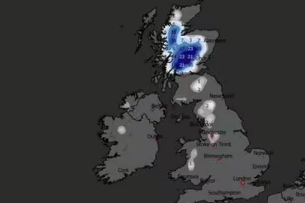
Maps from WXCharts, using MetDesk data, show a wintry blast hitting Britain next Wednesday (December 10), with Scotland bracing for 23cm (nine inches) of snow. The heaviest falls are expected in the Highlands, Argyll and Bute, Perth and Kinross, Stirling and west Aberdeenshire, with snow depths of 16-23cm forecast at 6am.
Parts of Cumbria, Northumberland and North Yorkshire could also see a light dusting. Temperatures that day are also set to be chilly, in the single digits across the UK by 6pm. In England, Wales and Northern Ireland, these range from 2-8C while in Scotland the mercury plunges to -1C to -3C, according to WX Charts.
The Met Office‘s long-range forecast for December 5-14 suggests any snowfall during this period is likely over higher ground, the Express reports In it’s long range forecast, the Met Office says: “Likely a continuation of the unsettled conditions see for much of the week. Initially a weakening frontal zone will bring cloud and some patchy rain and drizzle, mostly to northern and eastern areas.
“Following this winds are likely to fall light, and this could allow some fairly widespread mist and fog to form on Friday morning. However this should readily lift as winds begin to freshen once more ahead of a further band of rain expected to reach western areas later on Friday.
“This could bring a spell of locally heavy rain as it moves east across the country, particularly on hills exposed to the strong southerly winds. Thereafter likely to remain unsettled into the weekend, with further rain or showers for most. Temperatures not far from average throughout.
Meanwhile, the Met Office warns that today will be wet and windy. Its forecast for today reads: “England, Wales and parts of southern Scotland will be cloudy with some heavy rain, particularly in the west. Windy for many. Coastal gales. Brightening up elsewhere with the odd shower.”
Four weather warnings are in place for Monday, including a “danger to life” amber rain alert for central and south Wales, running from midnight for 24 hours. Areas affected by the amber alert include Blaenau Gwent, Bridgend, Caerphilly, Cardiff, Carmarthenshire, Merthyr Tydfil, Monmouthshire, Neath Port Talbot, Newport, Pembrokeshire, Powys, Rhondda Cynon Taf, Swansea, Torfae and Vale of Glamorgan.
Two yellow weather warnings for rain cover large parts of the country from midnight on Monday until 3am on Tuesday, including the East Midlands, North West England, SW Scotland, Lothian Borders, Yorkshire and Humber, London and South East England, South West England, Wales and the West Midlands.
A third yellow alert for rain, in place until 9pm on Monday, covers Central, Tayside & Fife, North East England, North West England, SW Scotland, Lothian Borders and Strathclyde. From Tuesday to Thursday, the national weather service expects clearer skies with scattered showers, mostly in the west, before “more persistent rain” moves eastwards on Thursday, accompanied by breezy conditions.