Experts have warned Brits to keep their doors shut as Storm Floris is set to batter the country with winds of up to 90mph.
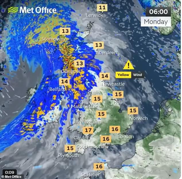
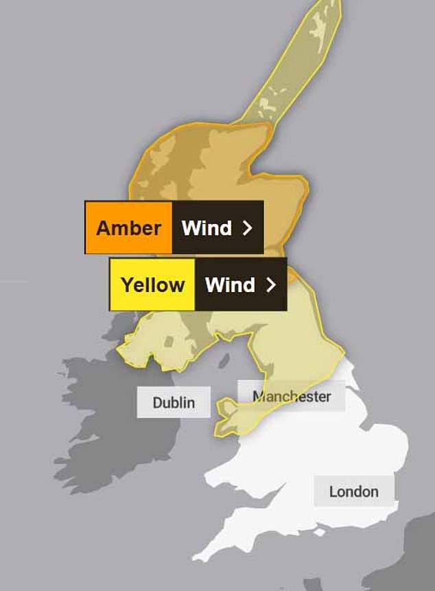
A yellow weather warning for wind has been issued for northern areas of the UK from 6am today until 6am tomorrow.
The warnings have been upgraded to amber for much of Scotland, lasting from 10am to 10pm.
It is the sixth named storm of the 2024-25 season, following Storm Eowyn in January and is expected to cause severe travel disruption.
Train operator LNER has told passengers not to travel north of Newcastle while Avanti West Coast has advised passengers not to travel north of Preston, warning it will be ‘heavily impacted’ by the weather.
The storm could also disrupt road, air and ferry services, and close bridges.
It is unusual to see a storm with such strong winds at this time of year. However it is the fourth August storm in three years, following storm Lillian last year and Antoni and Betty in 2023.
Much of Scotland will be battered by heavy rain and winds of up to 85mph, the Met Office said.

Some trains and ferry services have already been cancelled with more likely to be affected.
Western coastal areas are expected to bear the brunt of the storm although strong winds and rain will likely lead to disruption at Edinburgh’s festivals.
Network Rail said several lines will be closed from 12pm on Monday, with all other routes experiencing a reduced timetable and longer journey times.
Edinburgh – Fife/Perth/Dundee, Perth – Dundee/Aberdeen/Inverness and the West Highland Line are among the routes that will close at noon.
Ferry operator CalMac has also issued a series of cancellations ahead of the storm.
Met Office chief meteorologist Matthew Lehnert said: ‘Across the warning area, many inland areas are likely to see gusts of 40-50mph, with 60-70mph more likely at higher elevations and around exposed coasts in Scotland.
‘There is a small chance that some locations here could even record gusts of 85mph.’
The strongest winds will most likely affect Scotland on Monday afternoon and night but ‘there remains some uncertainty in the depth and track of Floris‘, a spokesperson added.
‘Winds will first ease in the west during later Monday but remaining very strong overnight until early Tuesday in the east.
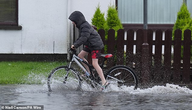
‘Heavy rain may also contribute to the disruption in places.’
The warning zone covers Scotland, parts of Northern Ireland, north Wales and the north of England.
Storm Floris is the sixth named storm of the 2024-25 naming season, which runs from early September to late August. January’s Storm Eowyn was the most recent.
A ‘danger to life’ alert is in place for most of Scotland today.
And a yellow warning for wind has also been issued for as far south as Manchester and north Wales – as well as the entirety of Northern Ireland between 6am and midnight tomorrow.
In a post on X offering advice on how to stay safe in a storm, the Met Office said: ‘Storm Floris is forecast to bring strong winds and heavy rain for parts of the UK from Monday. Stay #WeatherReady and check out some advice from our partners about keeping yourself, your home, and your garden safe.’
Other advice included ‘opening internal doors only as needed’ and ‘closing them behind you’, as well as parking vehicles in a garage, securing loose objects such as ladders, garden furniture or anything else that could be blown into windows – and staying indoors as much as possible.
Experts have also warned of potential travel disruption when the summer storm hits, with the Scottish Transport Secretary saying the unseasonable weather makes raising awareness even more important.
Avanti West Coast said services are likely to be impacted in Lancaster, Oxenholme, Penrith, Carlisle, Lockerbie, Motherwell, Haymarket, Glasgow Central and Edinburgh.
Tickets dated for Monday for these areas will be accepted on Sunday and Tuesday, it added.


Scottish Transport Secretary Fiona Hyslop said a meeting had been held on Friday to ensure the country is ready for the storm, adding: ‘Given the unusual timing, and the fact some people will be on holiday, travelling or perhaps unaware, we are trying to raise even more awareness than usual of this potentially disruptive storm.
‘Please check with operators as we do expect rail, ferries, roads and bridges to be disrupted on Monday across the country.
‘This is a slightly unusual situation for August, however the message is the same as winter – plan ahead, check your journey in advance, allow extra time, and don’t take any unnecessary risks.
‘Officials will be monitoring the situation and are ready to stand up the Multi Agency Response Team, if required.
‘I am grateful to those who are giving up their weekend and time off to help co-ordinate the transport sector’s response.
‘Traffic Scotland, Police Scotland, Sepa, local authorities and others will communicate any closures to the public and provide real-time updates.’
Scottish ferry operator CalMac has issued a series of cancellation warnings ahead of the storm.
‘Disruption to sailings is expected across our network on Monday August 4 due to forecasted strong winds across parts of Scotland’s west coast,’ it posted on X.


Elsewhere, motorists have been urged to slow down in poor weather and avoid exposed Highland and coastal routes.
Rod Dennis, of the RAC breakdown service, said: ‘This unseasonable bout of stormy weather will mean drivers in the north and west of the UK need to take extra care at the start of next week.
‘It’s the height of the holiday season, so those towing trailers and caravans, as well as those with roof and tent boxes, must ensure their loads are properly secured.’
Shaun Jones, of the AA, said: ‘If you’re planning a journey – especially through exposed or rural areas – it’s worth checking the latest forecast, allow extra time, and be prepared for the unexpected.
‘Keep both hands on the wheel, especially on open roads and motorways, and be mindful of high-sided vehicles and cyclists who may be more affected by gusts.
‘Watch out for fallen branches or debris, particularly in rural areas – this could be telltale signs of a fallen tree ahead.’
Met Office chief meteorologist Matthew Lehnert said: ‘Across the warning area, many inland areas are likely to see gusts of 40-50mph, with 60-70mph more likely at higher elevations and around exposed coasts in Scotland.
‘There is a small chance that some locations here could even record gusts of 85mph.’
The strongest winds will most likely affect Scotland on Monday afternoon and night but ‘there remains some uncertainty in the depth and track of Floris’, a spokesman added.
‘Winds will first ease in the west during later Monday but remaining very strong overnight until early Tuesday in the east.
‘Heavy rain may also contribute to the disruption in places.’
The warning zone covers Scotland, parts of Northern Ireland, north Wales and the north of England.