Weather modelling maps show more snow could be heading to the UK soon as all four home nations look set to be impacted during 21 hours of Arctic flurries
Another barrage of snow could soon hit the UK, with Brits facing blizzards lasting for a total of 21 hours.
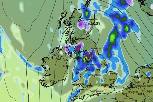
Advanced weather modelling maps show snow will first land in Scotland in the early hours of December 15, before slowly making its way southward and impacting Northern Ireland, Wales and parts of England.
By 9am, the GFS model maps indicate the most intense snowfall will be in southern Scotland, in Galloway Forest Park, as well as in the Lake District and the Pennines in northern England. Some lighter snow is also possible in Northern Ireland around this time.
Heavy snow looks set to come down in North Wales by 3pm on December 15, impacting Snowdonia in particular. Ireland also looks set for flurries, with snow possibly coming down in Dublin.
READ MORE: UK forecast shows snow for three days with 10 counties in England and Scotland hitREAD MORE: UK snow maps forecast snowfall in 15 cities TODAY – check your area
Areas that avoid snow can expect rain as this weather front moves down the UK. Most of central and northern England looks set to face some downpours throughout the day.
Snow coverage maps for 9pm on December 15 reveal the full extent of this Arctic blast, with snow settled on the ground in North Wales, Northern Ireland, northern parts of England and almost all of Scotland following 21 hours of flurries.
BBC Weather says for December 15 to 28: “There is very low confidence surrounding the second half of December, and not just because it’s a long way ahead. It’s also due to ongoing disturbances in the upper atmosphere and the uncertainty around their expected impacts as they trickle down to the troposphere, the layer in which our weather occurs.
“Patterns could shift, and indeed there is a tentative expectation that high pressure could become more prevalent for a while across or near the UK and Ireland.
“This should lead to more infrequent precipitation, so conditions could be drier than normal for a while before Christmas. High pressure alignment will dictate what happens to temperatures.
“Current indications are for them to be near or slightly above normal, but with some clearer and calmer nights there could be more frost and fog. There is a risk that high pressure could build more strongly at higher latitudes, which would bring a possibility of colder outbreaks later. On the other hand, if high pressure were to slip away the wetter conditions could return, so there is a lot yet to resolve.”
The Met Office says there is a chance of snow in some parts of the country in the second half of December. Its forecast for December 16 to 30 states: “There is a greater chance of spells of high pressure during this period, bringing more in the way of dry weather compared to the unsettled patterns we are likely to see through the first couple of weeks of December, which also increases the chances of overnight fog and frost.
“There will probably still be some spells of rain, showers, and stronger winds though, especially in the west. Hill snow is also a possibility, mainly in the north. Overall, near or slightly above average temperatures are most likely, though some colder spells are also possible, especially should any prolonged settled spells develop.”