Up on Langley Common the wind is rising. The tussocks under my boots cover the Maiden Way, perhaps the highest Roman road in Britain, but the sense of being close to the sky – today a simmering grey – remains as palpable as it would have been 2,000 years ago. Looking north, a rainbow arcs across the horizon, the full reach of it clearly visible from this high ground. Buffeted by the squall with every step, it feels as though I’m striding across the top of the world, which is apt, since I’m following the new Roof of England Walk.
This 188-mile, multi-day trail was developed by the North Pennines national landscape team, and launched in September. Taking in lofty footpaths and some of the best-loved elements of the North Pennines – among them High Force, Cross Fell, High Cup Nick, the Nine Standards and England’s highest pub, the Tan Hill Inn – the aim is to showcase this sometimes overlooked corner of the country.

“It’s a blank on the map for a lot of people, a huge area between Hadrian’s Wall and the Yorkshire Dales that they don’t really know,” says Shane Harris, the project’s lead, when I meet him after my walk for a bowl of cauliflower soup at Stanhope’s Root and Branch community cafe. “The North Pennines is a historic, vibrant landscape and a Unesco Global Geopark. This walk is about introducing more people to it.”
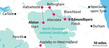
Starting and ending in Appleby-in-Westmorland, the walk loops through the moors, meadows and riverbanks of County Durham, Cumbria and Northumberland – the three counties of the North Pennines national landscape – plus a corner of the Yorkshire Dales national park. Its 14 legs have been designed to work as day walks or as a longer trail, and to link up with public transport. And most run between a town or village, so there’s somewhere to stay at the end of a day’s fairly remote walking.

I’m hiking a 50-mile section in just over three days, from Alston, in Cumbria, to Edmundbyers, in County Durham, via Haltwhistle, Allendale and Blanchland, all in Northumberland. Alston, touted as England’s highest market town, is also one of its prettiest, bustling with independent shops, cafes and (as of this month) a pint-size wine bar, Walter’s. It’s also home to the recently spruced-up Alston Hostel (dorm beds from £30, private rooms from £40pp), where I’m staying. Taken over two years ago by Mat Austin and his partner Claire, they aim to provide a homely experience, hence home-cooked meals and a welcome from Poppy the puppy.
The Pennine Way passes right behind the building – one of several long-distance paths the Roof of England Walk merges with along its course – and it’s this I follow the next morning. I leave the shelter of Alston’s coppery, tousle-headed trees and head up onto Langley Common. A bank of rain blows in, muting the landscape to monochrome, and I scurry on to Gilderdale Burn, crossing from Cumbria into Northumberland.
A little further on the embankments of Epiacum, a former Roman fort, loom out of the drizzle. I detour hurriedly to nearby Nook Farm Shop for a hot coffee. The rain ebbs as I leave and soon I’m into my stride, following drystone walls and burns down to Slaggyford via a long, broad sweep of whisky-coloured river.

The Kirkstyle Inn gastropub is nearby, but my route leads in the other direction, over hay meadows and moorland down to the banks of the South Tyne, where Featherstone Castle’s gothic bulk sits draped in mist. Following the river into Haltwhistle, I’m so soaked when I arrive that I look like I’ve been swimming in it.
“Ooh, bedraggled!” declares the owner of the Old School House B&B (twins from £120 B&B), whisking my waterproofs to the drying room and my sodden boots to the boot dryer. “As well as this new walk, we’re on the Pennine Way, Hadrian’s Wall Path and Land’s End to John o’Groats, so we’re used to walkers,” Kate says.
The following morning, at a breakfast table laid with bone china and his own-recipe granola, her husband Ian serves me a winning shakshuka. Outside it’s bright and most of the morning’s route is on country lanes. Beyond Haltwhistle, I pass elegant stone farmhouses, cottage gardens brimming with flowers and glimpses of rickety Unthank Hall. On a ridge beyond it, I open my flask of tea and watch rabbits bounding through the dew. I realise I’m completely alone, and relish it.
Past Willimoteswick Castle, I arrive at pretty Beltingham. Following one of the walk’s purple lapwing signposts, I dip down into Allen Banks. Cared for by the National Trust since 1942, this woodland is spectacular in autumn, its river gorge shimmering with bronze, copper and gold.

Climbing out of the woods, I’m met with a huge upland meadow, its peachy grasses rippling in the wind. It’s another few miles to Allendale. This former lead mining settlement switched to tourism in Edwardian times, after the last mines closed. I’m staying at the Lion House, a pub in the market square with two newly renovated guest rooms (en suites from £120 room-only). Each New Year, local guisers parade through the square carrying flaming tar barrels on their heads, but it’s quiet this evening. Landlord Dave welcomes me in, and his partner Maureen brings me a bowl of warming vegetable soup.
The following morning I open the shutters on to a sweeping view of the square … and more dark clouds. A storm is forecast and I need to be quick if I’m going to beat it. Scrambling on to moorland above the town, I startle grouse after grouse, their bark-quacks echoing in my ears as I drop down into the hamlet of Whitley Mill and on into Slaley Forest. It’s a long climb here, past thick tracts of Scots pine and blue spruce that are home to red squirrels. At the top the trail spits me out into the wind-scrubbed heather of Blanchland Moor. The view reaches all the way to Derwent reservoir but the sky is glowering, heavy and low, so I press on.
The clouds don’t burst and I’m still dry as I walk into Blanchland, a huddle of dainty stone buildings in the crook of a small valley. The village was created in the 18th century from the remains of a medieval abbey, and with smoke curling from chimneys and doors painted a regulation plum, it feels like a mirage. What was once the guesthouse for the abbey is now a hotel, the Lord Crewe Arms (doubles from £205 B&B), and as I click the latch on its ancient door, there’s a sense of entering another world.

In my room, there’s homemade shortbread in a jar and fresh milk by the kettle; downstairs is a vast open fire. After dinner in the restaurant – meltingly soft roast venison with homegrown kale – I peek out at the storm-cleared skies and am rewarded with a swathe of bright stars: there are no street lights in Blanchland, and it has some of the darkest skies in the country.
From here, it’s just over five miles to Edmundbyers. There’s a savage wind as I follow the trail up Buckshott Fell, but the sunrise has flushed the colour back into the land. From a ridge on the moor I look out over 360 degrees of purple, gorse and slate, and realise I’ve been approaching the North Pennines all wrong. There may be history and wild beauty along its path, but this is a walk for looking up, rather than down – to the ever-changing skyscape of rainbows, storm clouds, sunrises and stars on the roof of England.
The walk was organised by North Pennines national landscape. Further information at roofofenglandwalk.org.uk